
A destructive earthquake occurred in southeastern Afghanistan at 01:25 am local time on Wednesday morning (22/06/22; local time in the Czech Republic at 22:55 on Tuesday evening 21/06/22). The earthquake had a magnitude of 6.1 and was located in the mountainous border region between Afghanistan and Pakistan, about 200 kilometers to the south of Kabul. Local authorities have reported at least 1000 casualties and 1500 injured people to date, with many houses in the area completely destroyed.
Why was this earthquake so destructive, despite its relatively moderate magnitude?
This is likely due to several factors. Firstly, the earthquake was located at a shallow depth of only about 10 km depth (although some services reported a larger depth of around 50 km), which led to strong shaking in its direct vicinity. Secondly, most houses in the region are constructed from mud bricks and similar basic material and do not satisfy any earthquake safety standards. Thirdly, since the earthquake occurred in the middle of the night, nearly all people were inside their houses, when they collapsed.
Afghanistan and Pakistan frequently experience earthquakes, which are a consequence of the collision between the Indian and Eurasian plates. This collision, which initiated about 50 million years ago, formed the highest mountains (Himalaya) and plateau (Tibet) on Earth. The southeast Afghanistan earthquake is located close to the western edge of this collision, where the Indian plate moves horizontally past the Eurasian plate toward the northeast with a speed of 3.4 cm per year. This relative motion leads to high rates of earthquake activity in the region.
Given the remote location of the earthquake, the ongoing aftershock activity and the complicated political situation in the area, it will likely take some time until the actual extent of the damage is known.
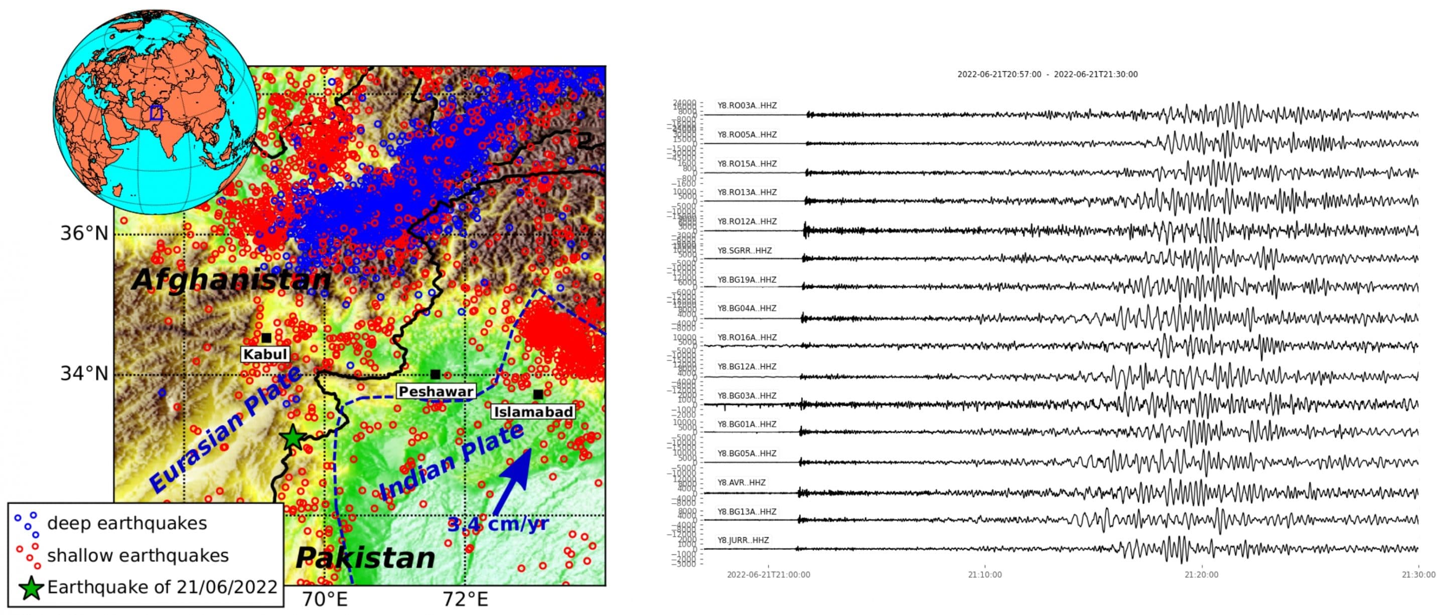
Left figure: Location of the southeast Afghanistan earthquake (green star). Black thick lines are national boundaries, the blue dashed line traces the approximate location of the plate boundary between Eurasian and Indian Plate. Red and blue circles show shallow and deep earthquakes that have occurred between 1995 and 2022. Right figure: Recordings of the earthquake at temporary stations of the MOBNET pool of the Institute of Geophysics installed in June 2022 in Romania and Bulgaria within european AdriaArray initiative (Jaroslava Plomerová, Luděk Vecsey)
Author: Christian Sippl